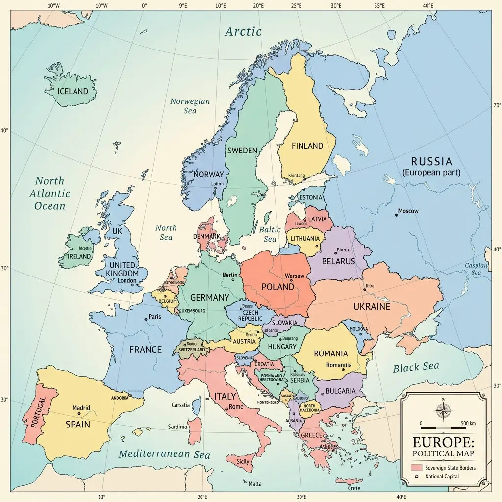
Europe's borders have shifted dramatically over the past century, and this political map of Europe shows exactly where they stand today. From the nine-country border ring around Germany to the contested lines through Cyprus and the Balkans, every boundary drawn here reflects the current internationally recognized status as of 2026. Click any country on the interactive map above to see its capital, population, and the political context behind its borders.
Political Boundaries Across Modern Europe
A political map differs from a physical or topographic map in one fundamental way: it shows human-drawn boundaries rather than natural features. The 44 countries on this political map of Europe represent the current consensus of international recognition, though several borders remain actively disputed. The map uses consistent color coding to distinguish between EU member states and non-EU nations, making it easy to see the political landscape at a glance.
Europe's political geography is uniquely dense — nowhere else on Earth do so many sovereign nations occupy such a compact area. The average European country is smaller than the average US state, which means borders are closely packed and historically contested. Germany alone shares borders with nine other nations, the highest count of any European country.
Disputed Borders and Contested Territories in Europe
While most of Europe's borders are stable and internationally recognized, several significant disputes remain active. Crimea, annexed by Russia in 2014, is recognized by most of the international community as part of Ukraine. Kosovo, which declared independence from Serbia in 2008, is recognized by over 100 UN member states but not by Serbia, Russia, China, or several EU members including Spain and Greece. Northern Cyprus, occupied by Turkey since 1974, is recognized as an independent state only by Turkey. Transnistria in Moldova and South Ossetia and Abkhazia in Georgia are de facto controlled by separatist governments backed by Russia.
How European Borders Have Changed Since 1900
The political map of Europe has been redrawn more times in the past 120 years than in any comparable period. The Treaty of Versailles (1919) dismantled the Austro-Hungarian, Ottoman, and German empires, creating Poland, Czechoslovakia, Yugoslavia, and the Baltic states. World War II shifted Poland's borders westward by roughly 200 kilometers and divided Germany into East and West. The collapse of the Soviet Union in 1991 produced 15 new states, six of them in geographic Europe (Estonia, Latvia, Lithuania, Belarus, Ukraine, and Moldova). Yugoslavia's dissolution created seven successor states between 1991 and 2008. The most recent changes were Montenegro's separation from Serbia (2006) and Kosovo's declaration of independence (2008).
EU Members vs Non-EU Countries on the Political Map
Of Europe's 44 countries, 27 are current members of the European Union. The EU is a political and economic union — not a geographic definition. Notable non-EU countries include the United Kingdom (left in 2020), Norway and Switzerland (chose not to join), and Ukraine, which has been a candidate for EU membership since 2022. Turkey has been a candidate since 1999 but negotiations have stalled. The Schengen Area, which allows passport-free travel, overlaps with but is not identical to the EU — non-EU members Norway, Iceland, Switzerland, and Liechtenstein are part of Schengen, while EU members Ireland, Cyprus, Bulgaria, and Romania are not fully integrated.
Frequently Asked Questions
What does a political map of Europe show?
A political map of Europe shows the boundaries between sovereign nations, the locations of capital cities, and the names of each country. Unlike a physical map that shows terrain and elevation, a political map focuses on human-defined borders and administrative divisions. This political map includes all 44 European countries with their current internationally recognized boundaries.
How many borders does Germany share with other countries?
Germany shares land borders with nine countries, making it the European nation with the most direct neighbors. These countries are Denmark to the north, Poland and the Czech Republic to the east, Austria and Switzerland to the south, and France, Luxembourg, Belgium, and the Netherlands to the west.
Which European borders are currently disputed?
Several European borders remain subject to dispute. The most notable include the status of Crimea between Ukraine and Russia, the border between Kosovo and Serbia following Kosovo's 2008 declaration of independence, the division of Cyprus between the Republic of Cyprus and the self-declared Turkish Republic of Northern Cyprus, and the borders of the breakaway regions of South Ossetia and Abkhazia in Georgia.
When were Europe current political borders established?
Most of Europe's current borders were established through a series of major political events in the 20th century: the Treaty of Versailles (1919), the post-World War II settlements (1945), the dissolution of the Soviet Union (1991), the breakup of Yugoslavia (1991-2008), and the peaceful separation of Czechoslovakia (1993). The newest recognized border change was Montenegro's independence from Serbia in 2006 and Kosovo's declaration of independence in 2008.
What is the difference between Europe and the European Union on a political map?
Europe is a geographic continent containing 44 countries. The European Union is a political and economic union of 27 of those countries. A political map of Europe shows all 44 countries regardless of EU membership. Countries like Norway, Switzerland, the United Kingdom, Ukraine, and Russia are part of geographic Europe but not EU members.
This political map of Europe is built from Natural Earth public-domain data and updated to reflect current international boundaries. For a broader view of all countries with capitals and population data, see the Europe map with countries and capitals. To explore how countries cluster geographically, visit Europe map by region. Test your knowledge of European political geography with the Europe map quiz.
Static Illustration of the Political Europe Map
For reference or sharing, here is a high-resolution static political map of Europe showing country borders: