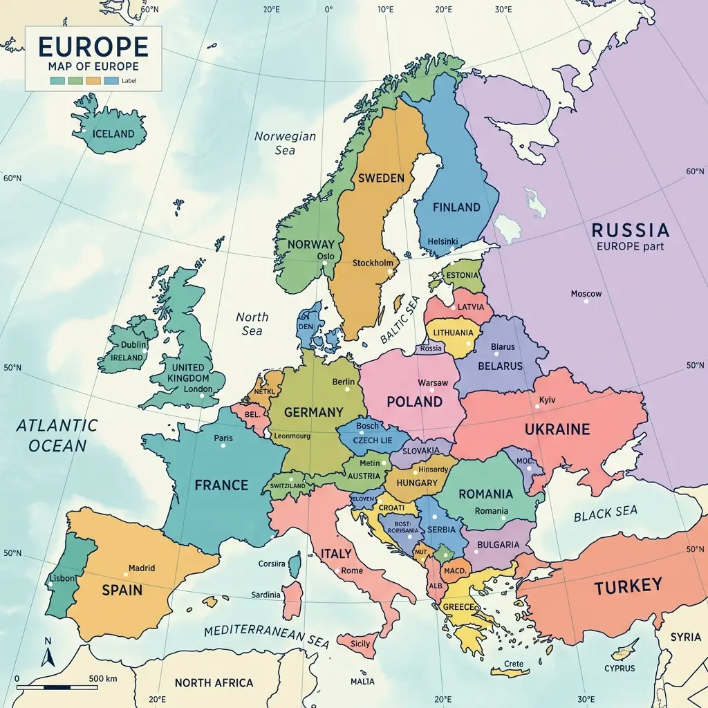
Europe's 44 countries are commonly grouped into five broad geographic regions, and this Europe map by region breaks them down with country lists and key data for each. Whether you are studying geography, planning travel across multiple countries, or simply want to understand how the continent is organized, the regional breakdown below covers Western Europe, Eastern Europe, Northern Europe, Southern Europe, and Central Europe — following the United Nations geoscheme with common cultural adjustments where the UN classification diverges from everyday usage.
Western Europe Map and Countries
Western Europe includes the continent's economic powerhouses along the Atlantic seaboard and the Rhine corridor. Countries: France, Germany, Belgium, Netherlands, Luxembourg, Austria, Switzerland, Monaco, and Liechtenstein. This region has a combined population of approximately 200 million and accounts for the largest share of the EU's GDP. The Euro is the dominant currency, with Switzerland (Swiss Franc) as the notable exception. Western Europe is characterized by high standards of living, dense transportation networks (including the TGV, Thalys, and ICE high-speed rail systems), and centuries of colonial and industrial history that shaped the modern world.
Eastern Europe Map and Countries
Eastern Europe stretches from Poland's western border to the Ural Mountains of Russia. Countries: Belarus, Bulgaria, Czech Republic, Hungary, Moldova, Poland, Romania, Russia (European portion), Slovakia, and Ukraine. This is the most geographically vast region, dominated by Russia's European territory. Since the fall of the Soviet Union in 1991, most Eastern European countries have transitioned to market economies, with Poland, Czech Republic, and Hungary joining the EU in 2004. Ukraine's ongoing situation has significantly reshaped the region's political landscape since 2022. The population of Eastern Europe exceeds 290 million when Russia is included, making it the most populous European region by a wide margin.
Northern Europe Map and Countries
Northern Europe encompasses Scandinavia, the Nordic countries, the British Isles, and the Baltic states. Countries: Denmark, Estonia, Finland, Iceland, Ireland, Latvia, Lithuania, Norway, Sweden, and the United Kingdom. This region is known for high standards of living (the Nordic countries consistently top quality-of-life indices), long coastlines, and low population density outside of major cities. The climate ranges from maritime (UK, Ireland, coastal Scandinavia) to subarctic (inland Finland and Norway, Iceland). The Nordic countries — Denmark, Finland, Iceland, Norway, and Sweden — are sometimes grouped together as a sub-region with particularly close cultural and political ties.
Southern Europe Map and Countries
Southern Europe lines the Mediterranean Sea and includes the Balkan Peninsula. Countries: Albania, Andorra, Bosnia and Herzegovina, Croatia, Cyprus, Greece, Italy, Kosovo, Malta, Montenegro, North Macedonia, Portugal, San Marino, Serbia, Slovenia, Spain, Turkey (European part), and Vatican City. This is the most diverse region by country count, spanning from Portugal on the Atlantic to Cyprus in the eastern Mediterranean. Southern Europe is characterized by Mediterranean climates, historic civilizations (Greek, Roman, Byzantine, Ottoman), and tourism-dependent economies — Italy and Spain alone attracted over 130 million international visitors annually before the pandemic.
Central Europe Map and Countries
Central Europe is the most debated regional classification, with different sources drawing different boundaries. Core countries consistently included: Austria, Czech Republic, Hungary, Poland, Slovakia, Switzerland, and often Germany and Slovenia. Central Europe's identity is rooted in the Habsburg Empire (1282–1918), which united much of this area under a single political structure for over six centuries. Today, the Visegrád Group (Czech Republic, Hungary, Poland, Slovakia) is the most formal political alliance within Central Europe. Geographically, Central Europe is defined by its position between the Baltic Sea to the north, the Alps and Carpathians to the south and east, and the Rhine to the west.
Frequently Asked Questions
How is Europe divided into regions?
Europe is commonly divided into five regions: Western Europe, Eastern Europe, Northern Europe, Southern Europe, and Central Europe. The exact classification varies by source — the United Nations geoscheme, the CIA World Factbook, and common cultural usage each draw slightly different lines. The UN classification is the most widely referenced in academic and policy contexts.
Which countries are in Eastern Europe?
Under the UN geoscheme, Eastern Europe includes Belarus, Bulgaria, Czech Republic, Hungary, Moldova, Poland, Romania, Russia (European part), Slovakia, and Ukraine. Some classifications also place the Baltic states (Estonia, Latvia, Lithuania) in Eastern Europe, though the UN classifies them as Northern Europe. The definition of Eastern Europe is politically sensitive and has evolved significantly since the end of the Cold War.
What is the difference between Western and Central Europe?
Western Europe traditionally refers to countries like France, the United Kingdom, Belgium, Netherlands, Luxembourg, Ireland, and sometimes Germany. Central Europe typically includes Austria, Czech Republic, Hungary, Poland, Slovakia, Switzerland, and sometimes Germany and Slovenia. The distinction is partly geographic (Central Europe is landlocked or near-landlocked) and partly historical (the concept of 'Mitteleuropa' or Central Europe emerged as a distinct identity during the Habsburg era).
Which region of Europe is the most populated?
Eastern Europe has the highest total population due to Russia's inclusion (145+ million). Excluding Russia, Western Europe is the most populated region with Germany (84 million), France (67 million), the United Kingdom (68 million), and the Netherlands (17 million) contributing significant numbers. Southern Europe follows closely with Italy (60 million), Spain (47 million), and several mid-sized Balkan nations.
Is Turkey in Southern or Eastern Europe?
Turkey's geographic classification is debated because only about 3 percent of its territory (Eastern Thrace) is on the European continent, while 97 percent is in Asia. When included in European regional classifications, Turkey is sometimes placed in Southern Europe due to its Mediterranean coastline, or treated as a transcontinental country that does not fit neatly into any single European region.
This Europe map by region follows the classification methodology of the United Nations Statistics Division with adjustments for common cultural usage. For the full list of all 44 countries with capitals and population data, see the Europe map with countries and capitals. Explore any individual country on the interactive Europe map.
Static Illustration of the Regional Europe Map
For study or reference, here is a static visual representation of Europe divided into five geographic regions: