Europe has 44 countries, and this Europe map shows every one of them — click any country to see its capital, population, and borders instantly. Most map sites either give you a static image or bury the data three clicks deep; this one puts the full interactive map of Europe in the first viewport, no sign-up, no app download. Whether you are checking where Europe is located relative to Asia and Africa, studying for a geography exam, or planning a multi-country trip, the live map above answers it in seconds.
What This Europe Map Shows
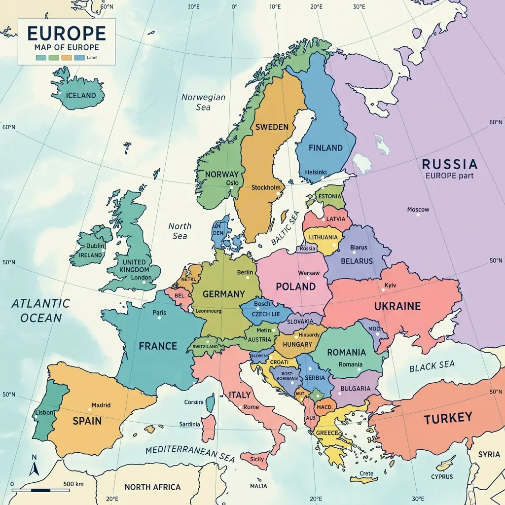
The interactive Europe map above displays all 44 sovereign nations of the European continent. Each country is a clickable region that reveals essential data: the official capital city, current population figures, total land area in square kilometers, the national currency, official languages spoken, and the timezone. Country borders are drawn from Natural Earth public-domain geodata, ensuring accuracy down to internationally recognized boundary lines. The map uses a Mercator projection centered on the continent, giving you a clear, proportional view from Iceland in the northwest to Cyprus in the southeast.
Every country shape responds to your cursor. Hover over any territory to see it highlighted in Harbor Mist teal, and watch the coordinate readout in the upper-right corner update in real time — a functional detail borrowed from professional cartographic tools, not just decoration. Click to open the detail panel, which slides in from the right margin like an annotation on a printed atlas.
How Many Countries Are on This Map of Europe
This map of Europe includes all 44 countries recognized by the United Nations as part of the European continent. That count covers the 27 current European Union member states plus 17 non-EU countries including the United Kingdom, Switzerland, Norway, Ukraine, Russia (its European portion), Turkey (its European portion), and the microstates of Vatican City, Monaco, San Marino, Liechtenstein, and Andorra. Kosovo, while not universally recognized, is included as the 44th territory because it operates as a de facto independent state with its own government, capital (Pristina), and borders.
The distinction between EU membership and geographic Europe is important and often confused. The European Union is a political and economic union — a subset of the continent. Countries like Norway and Switzerland are fully European by geography but have chosen not to join the EU. Turkey straddles both Europe and Asia, with roughly 3 percent of its land area (Eastern Thrace) falling on the European side of the Bosphorus.
Where Is Europe Located (Asia, Africa and Maritime Borders)
Europe occupies the western fifth of the Eurasian landmass, roughly 10.18 million square kilometers. Its geographic boundaries are the Arctic Ocean to the north, the Atlantic Ocean to the west, the Mediterranean Sea separating it from Africa to the south, and to the east, the conventional line follows the Ural Mountains, the Ural River, the Caspian Sea, and the Greater Caucasus watershed. This eastern boundary is a geographic convention rather than a geological divide — unlike the clear water boundaries on the other three sides.
The narrowest point between Europe and Africa is the Strait of Gibraltar at just 14.3 kilometers wide, connecting the Mediterranean Sea to the Atlantic Ocean between Spain and Morocco. Europe and Asia meet along a roughly 2,500-kilometer line from the Kara Sea in the north through the Urals to the Caspian Sea. Several countries — Turkey, Russia, Kazakhstan, Azerbaijan, and Georgia — straddle this boundary, which is why "how many countries are in Europe" does not have a single universally agreed answer.
Europe by Region (East, West, North, South, Central)
Europe is commonly divided into five broad regions, though the exact boundaries vary depending on whether you follow the United Nations geoscheme, the CIA World Factbook classification, or common cultural usage. Western Europe includes France, Germany, Belgium, the Netherlands, Luxembourg, Austria, and Switzerland. Eastern Europe spans Poland, Ukraine, Romania, Belarus, Moldova, and the Baltic and Balkan states. Northern Europe covers Scandinavia (Norway, Sweden, Denmark, Finland, Iceland) plus the Baltic republics. Southern Europe takes in the Mediterranean nations: Italy, Spain, Portugal, Greece, and the western Balkans. Central Europe is the most debated category, typically including the Czech Republic, Hungary, Slovakia, Austria, and sometimes Poland and Switzerland.
For a deep dive into each region with dedicated country tables and maps, see the full Europe Map by Region page.
Frequently Asked Questions
How many countries are in Europe?
Europe has 44 internationally recognized countries. This includes sovereign states from Iceland in the northwest to Cyprus in the southeast, and from Portugal in the southwest to Russia in the east. The European Union, which is a political and economic union, currently has 27 member states out of these 44 countries.
What is the largest country in Europe by area?
Russia is the largest country in Europe by area, with its European portion covering approximately 3.97 million square kilometers. If counting only countries entirely within Europe, Ukraine is the largest at 603,500 square kilometers, followed by France at 551,695 square kilometers.
What is the most populated country in Europe?
Russia is the most populated European country with approximately 145 million people, though most of its population lives in the European part. Germany is the most populated country entirely within the European Union with about 83.8 million inhabitants, followed by France with around 67.4 million.
Where is Europe located on the world map?
Europe is located in the Northern Hemisphere, occupying the western portion of the Eurasian landmass. It is bordered by the Arctic Ocean to the north, the Atlantic Ocean to the west, the Mediterranean Sea and Africa to the south, and Asia to the east. The conventional boundary between Europe and Asia runs along the Ural Mountains, Ural River, and Caspian Sea.
What are the five regions of Europe?
Europe is commonly divided into five geographic regions: Western Europe (France, Germany, Belgium, Netherlands, etc.), Eastern Europe (Poland, Ukraine, Romania, etc.), Northern Europe (Scandinavia, Baltic states, etc.), Southern Europe (Italy, Spain, Greece, Portugal, etc.), and Central Europe (Austria, Czech Republic, Hungary, Switzerland, etc.). The exact classification varies by organization.
Is the United Kingdom still part of Europe?
Yes, the United Kingdom is geographically part of Europe. While the UK left the European Union (Brexit) on January 31, 2020, it remains a European country by geography. The EU is a political and economic union of 27 member states, which is separate from the geographic definition of the European continent.
This Europe map is built from public-domain Natural Earth geodata, with country information sourced from open data APIs. Whether you landed here searching for a map of Europe, a map of European countries, or wondering how many countries are in Europe, the interactive tool above puts the answer at your fingertips. Explore the political map of Europe for current border details, test your knowledge with the Europe map quiz, or download a printable blank Europe map for classroom use.
Static Illustration of the Europe Map
For quick reference, study, or sharing, here is a high-quality static visual representation of the Europe Map: